CAMDEN COUNTY'S PROFESSOR OF PLACENAMES
Inside Historian William Farr's 40-Year Quest to Get it Right
By Hoag Levins ...| ...March 27, 2003

CAMDEN, N.J. -- In 1664, when the British seized control of the land east of the Delaware River and named it New Jersey, there were several thousand Dutchmen,
|
|
Photo: Hoag Levins |
|
|
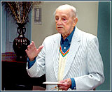
Historian and author William Farr discussing waterways in the Camden County Historical Society's Boyer Auditorium. The event was the latest in a monthly lecture series sponsored by the County Freeholders and the New Jersey Historical Commission.
|
|
Swedes and Finns living in that wilderness.
Many of these rugged-individualist fur trappers bestowed names on their local landmarks -- often different names in different languages for the same thing. Making it worse was the fact that many who used the same language spelled the words differently.
Nameplace puzzles
The maps of these early pioneers document the beginnings of the idiosyncratic spirit and haphazard practices that, over the next 300 years, generated a bewildering thicket of nameplace puzzles, contradictions and mysteries throughout the file drawers of virtually every library, historical society, deed room and tax office in the region.
The full extent and implications of this placename confusion are not well understood by the general public even as they continue to frustrate the authors, journalists and other researchers who write the documents that tell our history.
In 1964, then-Bellmawr attorney William Farr became the latest novice historian to grapple with this problem. Motivated by the celebration of New Jersey's tercentenary, he wanted to research and write about local history but could not find clear documentation of a variety of waterway, town, road and structure names.
"I was looking through town histories published for the tercentenary, older histories of Camden County, and newspapers and magazine articles, but everything was a secondary source," explained Farr in an appearance as March's featured speaker in the Camden County Historical Society's lecture series. "And so many times what was in print was wrong."
'Irresistible urge'
"I found that people have an irresistible urge to create a story for the name of a place even if they don't actually know the facts," said Farr. "And if they can get their created story printed,
|
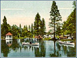
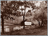
| Image: CCHS |
One of many county waterways that have disappeared is Wood Lynn Lake, which was a popular public park on the southern edge of Camden at the turn of the 20th century.
| other people will read it, believe it and repeat it."
Reared in Barrington, he was surprised to learn that despite the widespread belief that the town was named after the Barring family, there was no such family. "But there it was in print" in local books and pamphlets, he said. The actual source of the name, he discovered, was the hometown of one of the original developers of the community -- a man from Great Barrington, Mass.
"I came to realize how much of what is published does not cite the basis of what it presents as facts," said Farr. "It upset me that people were putting things in print without saying where they had obtained the information. I wanted to know. I wanted to verify it; look it up myself and see if it was correct."
As a result, the now-retired former partner in the law firm of Farr, Reifsteck & Wolf began researching 300 years of the documentation of area placenames. His goal was to find and cite the exact primary source of every fact. In addition, he actually traveled to each site to locate it exactly -- no easy feat given that many of the landmarks he was researching have vanished or been transformed beyond easy recognition.
40 years of research
The 83-year-old has been conducting this research project for almost 40 years. He originally intended to include several counties in the work but later realized the scope of that undertaking was too large. He narrowed the focus to all placenames in Camden County and then, a few years ago, narrowed it further to waterways placenames.
Earlier this year his first book, Waterways of Camden County, was published by the Camden County Historical Society. It is a densely detailed reference guide to all that is documented in primary sources about 250 waterways across the 227-square-mile county.
"All around the world," he explained, "the oldest placenames are those of
|
|
Image: CCHS |
|
|
Cooper's Creek evolved from a major avenue of maritime commerce in the 18th and 19th centuries into a county park system. Here, a bridge at Farnham Park in the 1950s.
|
|
waterways. Some have been used for thousands of years. Here in Camden County, the early settlements were all along rivers and streams because that is how people traveled around."
He noted that it is now largely forgotten that in the 18th and 19th centuries, many southern New Jersey towns like Haddonfield were actually port cities with wharf complexes and a waterfront business environment. The waterways -- like the then-navigable Cooper's Creek -- were the primary means for transporting commercial cargo back and forth.
Water world
Many of the Quakers in the county's early settlements went to meeting by boat, he said. They visited each other's homes by boat; received and sent most commercial goods by boat and even conducted their funeral ceremonies as waterborne affairs. Creeks, streams and rivers were the primary byways of everyday life. The Delaware River ultimately tied them all together as a broad matrix that allowed anyone to get virtually anywhere via water faster and more efficiently than by foot or horse.
Local swamps were equally important because of their thick growths of cedar trees as well as their sunken deposits of ancient cedar root systems and fallen trunks. Cedar, which is impervious to rot and insects, was a critical commodity for farmers who built everything from fences to irrigation water sluices from it.
"Nearly every farmer had a cedar swamp," said Farr. "I've studied the deeds for hundreds of cedar swamps and it looks to me that every inch of cedar swamp was taken and that most farms had a cedar swamp somewhere connected to them. It was a very significant aspect of our streams in the southern part of Camden County."
Southwest New Jersey is also a place heavily dotted with man-made ponds. Unlike neighboring Pennsylvania, which has dramatic uplifts of hills and mountains with cascading streams, south Jersey is a flat coastal plain. The only way our ancestors could harness the power of water for their grist and saw mills was by damming streams to create small
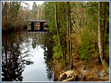
|
| Photo: Hoag Levins |
Near Atco, where the far edge of Camden County intersects the Wharton State Forest, one can still get a sense of what county waterways looked like long ago.
| lakes high enough to spill their contents down onto wooden mill wheels.
Invisible waterways
Over the decades, Farr said he worked with several different "field men" -- outdoorsmen who had long roamed the back roads and woods of south Jersey and could serve as landscape detectives. After finding all physical documentation -- maps, deeds, titles, etc. -- of a waterway, Farr would then begin the task of tracking it down. But many swamps, ponds and streams have dried up. Others have been engineered out of sight and are now contained in pipe systems that run beneath our strip malls, parking lots and housing developments.
His goal has been to find and explain the name of each of the geographical items related to waterways he has tracked down. Despite the dense detail of his book, he has not cracked all the mysteries, he told the Historical Society audience.
"Down on the upper reaches of the Mullica River at Atco," he said, "there is a place and a bridge called 'Jacques Bridge.' In documents it is spelled many ways. But look as I might, I have not been able to find out who Jacques was or how the place came to take his name."
Farr also described to the crowd how he carries a highly-detailed landscape of Camden County's wetter reaches in his mind. He said it is so real he can almost walk it, and, in one recent instance, actually went through the exercise of doing so.
Waterways of the mind
About two years ago when Farr had to have an MRI scan, he experienced an attack of claustrophobia as he was slid into the tight, body-length cylinder.
"When I went back to try it again, I had to come up with something to think about during the time I had to keep perfectly still with my eyes shut inside that tube," he said. "So, I traveled the Camden County water system in my mind. I started with Timber Creek and went up to the farthest water mill -- Timber Creek has two branches and two sets of water mills and I did them all. Then I went up Newton Creek, which has three branches, and then I did Cooper's Creek. The MRI was finished just as I was finishing up Pennsauken Creek."
|